Meta di Sorrento
Naturalistic itinerary
Above the road called Corso Italia, there is an unknown and still secret part of Meta. These are the old access roads to the Peninsular: Montechiaro, Casini, Alberi, Camaldoli and Arola. The WWF has studied their course and has inserted them into the eight excursions of the Peninsular.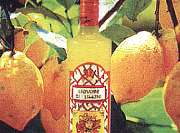 There are five stops on this walk which lasts four hours.
Montechiaro is the first. Here you can look out from numerous natural balconies of rare beauty. The production of "vino del sabato" (Saturday's wine), oil and agricultural tools is famous.
The mountain of Sant'Angelo, locally called "Casini", is the highest of these hills.
 The route unwinds and coasts the cultivated fields, then crosses a field of chestnut trees. The path descends and it is now possible to see Vico Equense with the top of the volcano Vesuvius in the background. Taking Via Petrignano, within twenty minutes you arrive in Alberi. In the past, this area of Meta hosted one of the first nautical schools in the Peninsular. The trail continues down the side of the parish church and then goes up Via Camaldoli. The hill of Camaldoli is so called in memory of an old monastery of the Camaldoli monks. To enter, you go through an old fort which unveils on the inside a large clearing with age-old holm-oaks. From the terrace you can enjoy a fantastic panorama which goes from the gulf of Naples to the sea at Salerno.
  A world rich with grape vines, olive trees and citrus fruits, slivers of light on an immobile sea, Mediterranean balm that the Maestrale (a cold and dry northwesterly wind) blows onto the sea, sweet hours of summer sunsets, shadows that fall from walls, churches and old buildings that are often marked with signs of fatigue and age. Looking down you can see the hamlets of Meta, Piano and Sant'Agnello. You will notice how modern buildings rise up next to old ones along the Corso Italia. This important roadway opened to vehicle traffic around 1840. Until then, the only possibility of access by land was by using the road from Alberi and the two descents from Arola to the localities of Casa Starita and the Lavinola glen. At the exit of the monastery of Camaldoli, the trail continues to the right along a track that leads to Via Raffaele Bosco.
 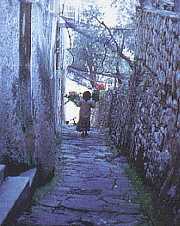 The road that comes from Seiano rises slightly and comes out in the centre of Arola. From here at the side of the church there is a cement road which goes down to the Lavinola glen. Lavinola glen cut out of the soft tufo (volcanic) rock by thousands of years of falling water constitutes one of the most prominent natural phenomenons. Trarivi is the last stop of this excursion. It is a predominantly agricultural area with a labyrinth of shady roads that rises up along the edge of Lavinola and it is concentrated mostly around an ancient tower of the same age as the ones at Punta Scutolo and Via Casa Iaccarino. Some authoritative scholars say that were used as look-out posts and garrisons for protection against raids by the Saracens via sea or the surrounding hills.
- Historical Itinerary
Naturalistic Itinerary
- Artistic Itinerary